ArduPilot NativeWeb + iOS · Free to start

PulseDroneYour ArduPilot drone management platform

Upload MAVLink logs, check no-fly zones, plan missions and replay flight footage — all in one place, on web and iOS.

4+
Regions covered
Web + iOS
Platforms
Free
To get started
Flight detail
Grid planner
Mission planner
YouTube flight replay
§ 01 / FEATURES

Everything you need to fly smarter.

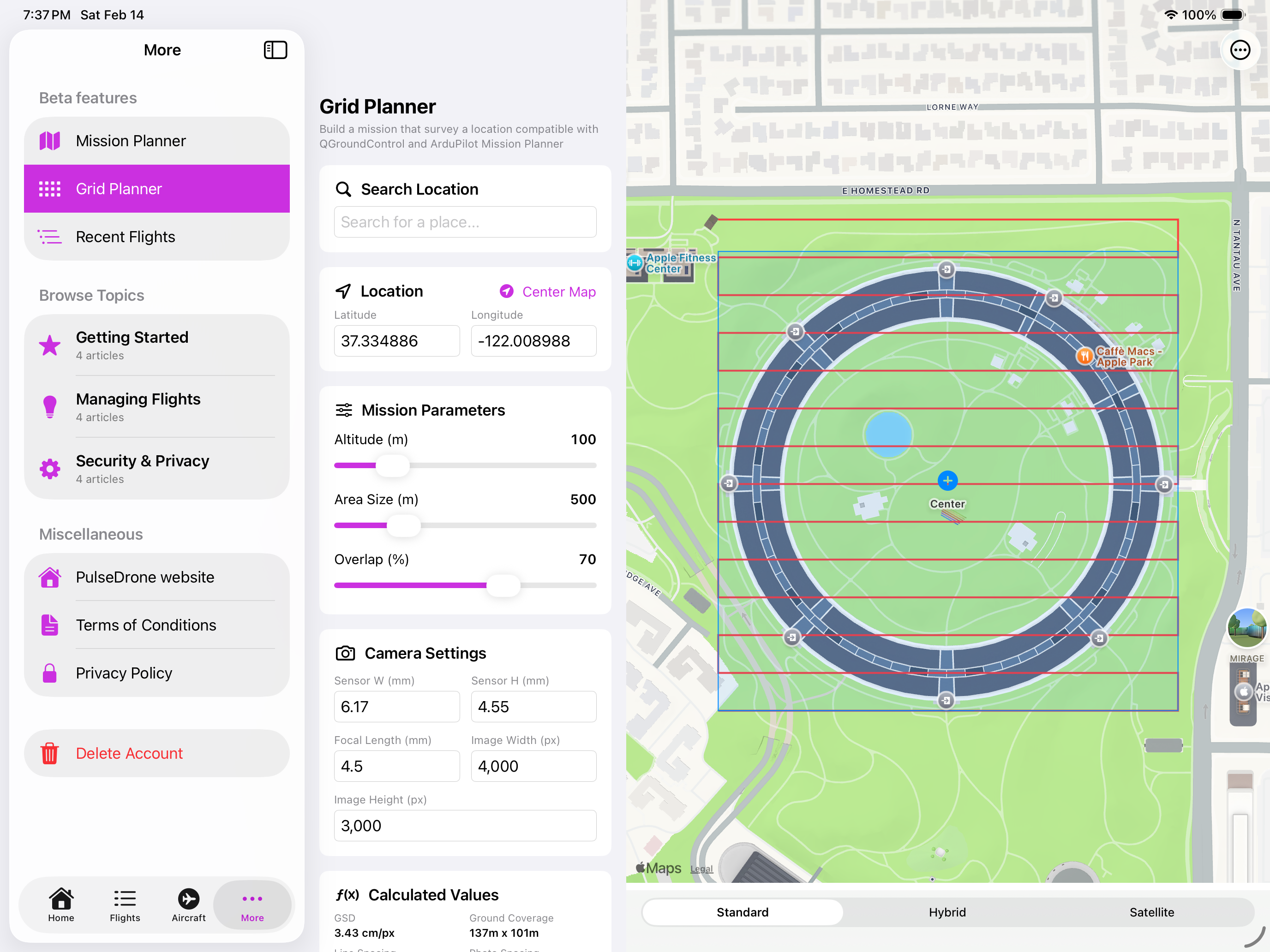
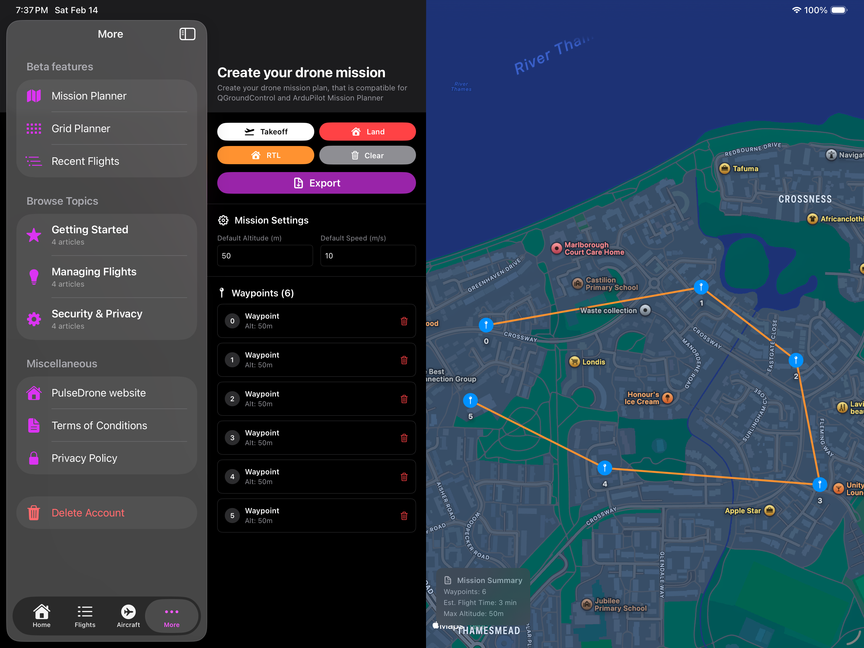
Four core tools — log analysis, airspace checks, mission planning and video replay — unified in one platform. Web and iOS, always in sync.

LOG-ANALYSIS

MAVLink Log Analysis

Drag and drop a .bin or .tlog. Altitude, speed, current draw, trip distance and airtime — extracted automatically.

PULSEDRONE · 01 / 04
CAPABILITY DETAIL
01Charts for altitude, speed and current draw
02Key stats: airtime, trip distance, max altitude
03Supports .bin and .tlog formats
04No parsing scripts or desktop tools needed

Available on web and iOS · Sign in with Google or Apple

PulseDrone harbour flight screenshot
§ 02 / LIVE TELEMETRY

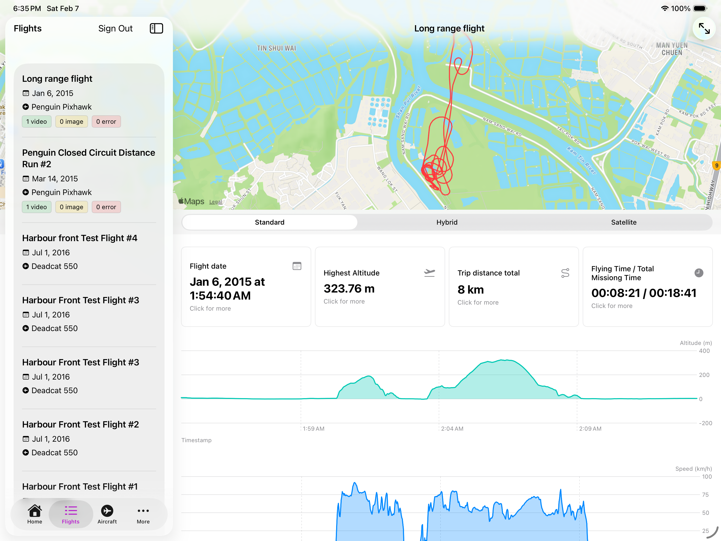
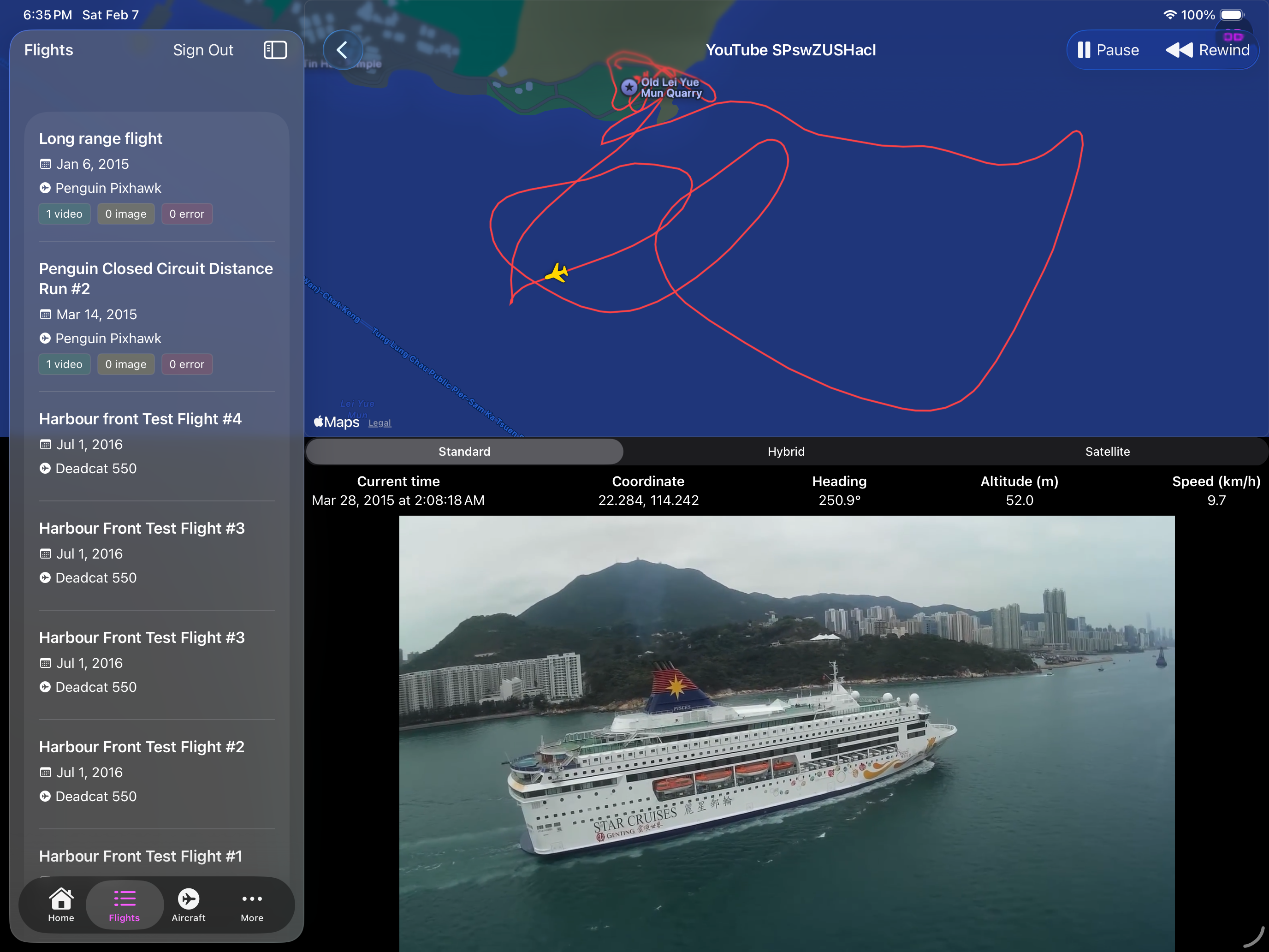
See your flight data exactly as it happened.

PulseDrone parses MAVLink logs and renders altitude, speed, current draw and heading in real time. Drop a .bin or .tlog — charts and key stats appear immediately, no configuration required.

PULSEDRONE · LOG ANALYSIS

From log file to insight, in seconds.

01
MAVLink log analysis
Drop a .bin or .tlog and PulseDrone extracts altitude, speed, current draw, trip distance and airtime automatically. No parsing scripts.
02
No-fly zone overlays
UK, Ireland, Hong Kong and Romania airspace built in. Know before props spin up. More regions onboarded every quarter.
03
Mission planner
Plot waypoints, attach MAVLink commands, export QGroundControl-compatible .plan files. Grid surveys in two clicks.
04
Video × telemetry replay
Sync on-aircraft footage to live flight data. Scrub once, see everything — altitude, heading, current — overlaid frame-accurate.
PULSEDRONE · LIVE FEED AC/GW-V22-004
Altitude AGL
318 m
Ground speed
22.4 m/s
Battery
74%
Heading
164°
MSN GW-MAY-14 · WPT 07/12T+ 00:24:18
§ 03 / REGIONS

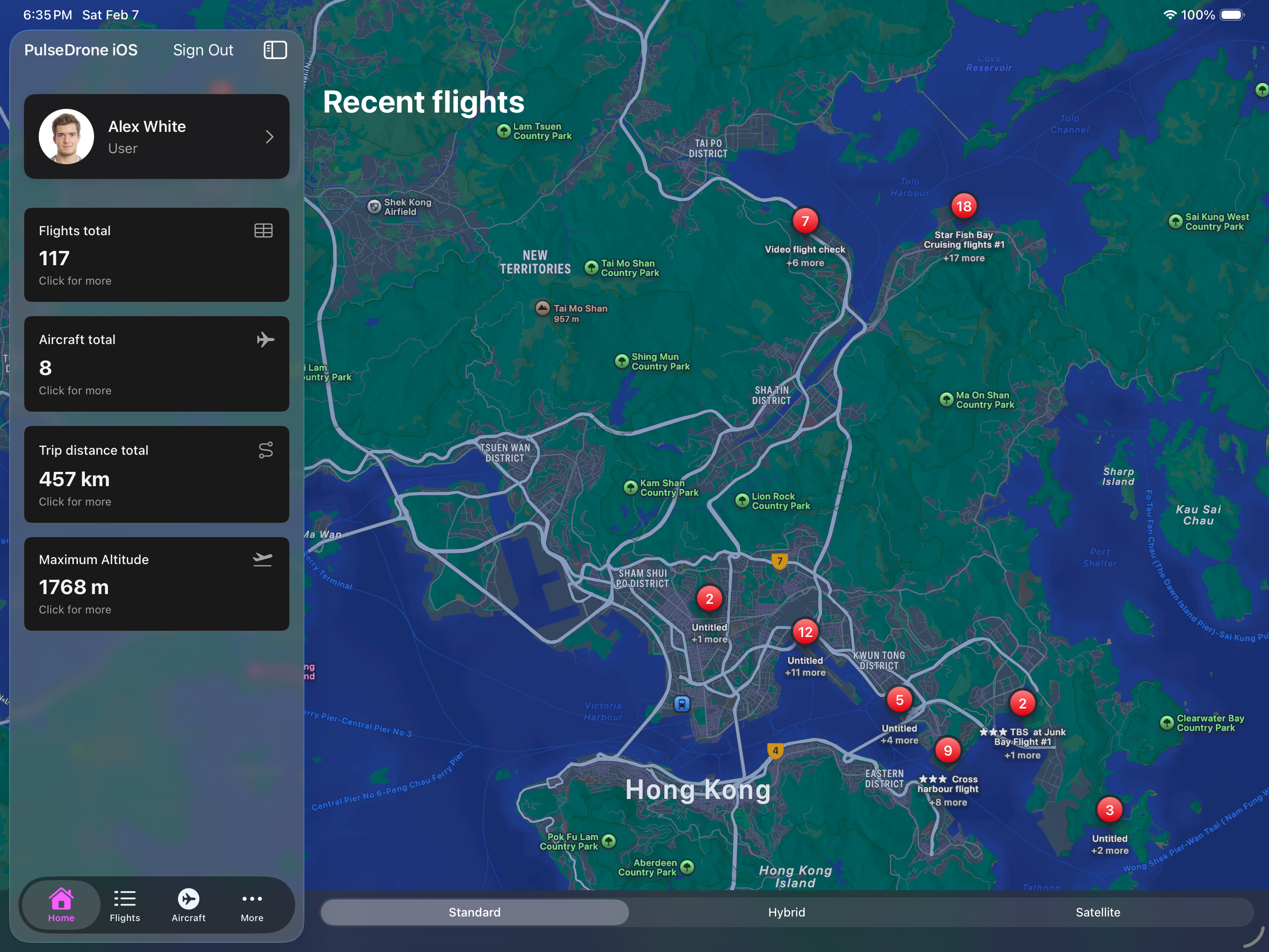
Flown in four regions. Written for twenty.

No-fly zone data built in for UK, Ireland, Hong Kong and Romania. Know exactly what airspace you're entering before props spin up. More regions added every quarter.

ACTIVE REGIONS
Live NFZ data
Restricted zones
Planned expansion
Coverage · Live
4 / 20+
Regions · Q2 2026
United Kingdom
CAA · CAP 722
Zones14,000+
StatusLive
Ireland
IAA · SI 563
Zones3,200+
StatusLive
Hong Kong
CAD · ANO
Zones800+
StatusLive
Romania
RCAA · EU 2019/947
Zones1,100+
StatusLive
LiveUnited KingdomCAA · CAP 72214,000+ zones
LiveIrelandIAA · SI 5633,200+ zones
LiveHong KongCAD · ANO800+ zones
LiveRomaniaRCAA · EU 2019/9471,100+ zones
§ 04 / HOW IT WORKS

Up and flying in three steps.

No setup, no desktop software, no parsing scripts. Upload a log, see your data, plan your next flight — all in the browser or on iOS.

STEP 01
Upload your log
Drag and drop a .bin or .tlog file from your ArduPilot flight controller. No account required to try — analysis starts immediately.
STEP 02
Analyse your flight
Review altitude, speed and current charts. Key metrics — airtime, trip distance, max altitude — are summarised automatically at the top.
STEP 03
Plan your next mission
Drop waypoints on the map, attach MAVLink commands and export a QGroundControl-ready .plan file. Check no-fly zones before you go.
§ 05 / GET STARTED

Start flying smarter, for free.

ArduPilot pilots worldwide use PulseDrone to analyse logs, check airspace and plan missions. Create your account in seconds — sign in with Google or Apple.